England now has a continuous walking route around its entire coastline and it has been officially inaugurated by King Charles. Stretching 2,689 miles, the King Charles III England Coast Path is being described by Natural England as the longest managed coastal walking route in the world, opening up extraordinary access to beaches, cliffs, dunes, salt marshes and historic seaside towns.
Quick takeaways
- King Charles has officially inaugurated the King Charles III England Coast Path
- The route stretches for 2,689 miles around the coast of England
- Natural England says it is the longest managed coastal walking route in the world
- More than 1,000 miles of new path have been created, with many other sections upgraded
- Around 80 per cent of the route is now open, with most of the rest due by the end of the year
- The path includes new access rights to some beaches, dunes and cliff tops previously out of bounds
- A new legal “roll back” provision means the route can move inland as the coastline changes
England’s coastline gets a landmark new walking route
King Charles has officially inaugurated a new coast path that will eventually allow walkers to trace the full outline of England, one cliff edge, harbour, estuary and beach at a time.
Known in full as the King Charles III England Coast Path, the route stretches 2,689 miles and, according to Natural England, is now the longest managed coastal walking trail in the world. For a country that has spent centuries peering fondly at the sea, building piers into it and eating fish beside it, this feels like a rather fitting development.
For the first time, the route creates a continuous trail around the whole of England’s coast. Walkers can now set off from almost any stretch of shoreline, turn left or right, and keep going with the sea as company for as long as their legs, optimism and weatherproof clothing will allow.
The path runs through some of England’s most varied coastal scenery. There are sandy beaches, salt marshes, dramatic cliffs, dunes and old seaside towns with just the right amount of faded grandeur. In other words, it offers a generous helping of the English coast in all its windswept, muddy, handsome unpredictability.
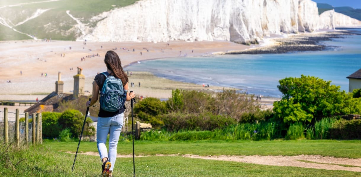
The King marks the occasion at Seven Sisters
The official inauguration took place at Seven Sisters in East Sussex, one of the most recognisable landscapes on the English coast and one that looks as though it was designed specifically to show off on postcards.
The King attended a reception hosted by the South Downs National Park Authority, where he also marked the announcement of a newly designated National Nature Reserve covering the famous chalk downland. He later walked a section of the newly completed path, joined by Natural England chair Tony Juniper and Environment Secretary Emma Reynolds.
Juniper described the coast path as a project that shows how public enjoyment, conservation, heritage, history and community can work together. It is the sort of statement that can sound rather official until you picture what it actually means in practice, which is families, walkers, birdwatchers and day trippers enjoying stretches of coastline that were previously difficult or impossible to reach.
Eighteen years in the making
This has not been a quick undertaking. The project was first initiated under Gordon Brown’s government and has taken 18 years and seven prime ministers to reach this point, which is enough political turnover to make any footpath seem positively steady by comparison.
Although large parts of the route already existed in one form or another, more than 1,000 miles of new path have been created. Other sections have been upgraded so that the route works as a continuous trail rather than a patchwork of promising bits joined by confusion.
That work has included resurfaced paths, removed stiles, newly built boardwalks and installed bridges. These may sound like small improvements until you imagine trying to walk hundreds of miles while repeatedly climbing awkward timber barriers or slithering through boggy gaps. Infrastructure, when done properly, is rarely glamorous, but it can be the difference between a good walk and a muttered vow never to leave the sofa again.
Natural England says around 80 per cent of the route is now open, with most of the remaining sections due to be completed by the end of the year.
New rights of access along the shoreline
One of the most significant parts of the project is not just the path itself, but the access that comes with it. Creating the route required new legislation through the Marine and Coastal Access Act 2009, as well as years of planning along the shoreline.
In many places, Natural England says new rights of access have opened up land between the trail and the sea that had previously been off limits. That includes stretches of beach, dunes and cliff tops that many people might once have admired from a distance without ever being able to wander onto them.
The path has also been designed with improved accessibility in mind. In practical terms, that means more people with reduced mobility should be able to enjoy sections of the route, which matters enormously on a trail intended to belong to the whole country rather than only to the sprightly and mud resistant.
Neil Constable, who led the project for Natural England, called it the best thing he will do in his working life. He said the true value of the path lies not simply in its total distance, but in the fact that anyone can go to the coast in England, turn in either direction and carry on beside the sea for as long as they like.
It is a lovely idea and also a very English one. Not grand, not flashy, just the quiet civilised pleasure of being able to walk somewhere beautiful without being told to stop.
Not entirely straightforward in places
Like the coastline itself, the route is not perfectly tidy from end to end. In a few places, walkers will still need to make small detours.
In north west England, for example, a ferry is needed across the Mersey. In south Devon, one stretch at the River Erme sounds particularly memorable. There is no bridge or ferry, and the land further upstream is privately owned and inaccessible. Walkers therefore have to wade across the river within an hour either side of low tide.
This is either gloriously adventurous or a very effective way to make people check tide tables more carefully. Either way, it is part of the character of the route. As Constable put it, it is all part of the experience.
Designed for a changing coastline
Perhaps the most forward looking aspect of the new trail is the way it has been designed to cope with climate change and coastal erosion.
For the first time in English law, the path can be moved inland when the coast shifts or erodes. Natural England refers to this as a roll back provision. The phrase is not especially poetic, but the idea is sensible. Coastlines move. Cliffs fall. Sea and land are in a constant, slightly bad tempered conversation. A fixed route beside a changing shore would not stay practical for long.
That flexibility has already proved useful. Near Charmouth in Dorset, a large section of the path on the cliffs was lost in early February after heavy winter rain caused a landslip. The path was closed and a diversion was put in place, but the diversion added around a mile and a half and, perhaps more offensively, sent walkers along roads.
Lorna Sherriff, who heads the team managing the South West Coast Path, said her team was able to agree a short rollback with the landowner and reopen the path within weeks. Without that provision, she said, it could have taken months.
A long-awaited moment for walkers
The Ramblers charity has been campaigning for greater access to England’s coastline since the end of the Second World War, so the completion of the path marks a significant moment.
Jack Cornish, director of England for the Ramblers, described the new route as transformational. He said it creates a band of access land between the trail and the high water mark, allowing people to leave the route to roam beaches, stop for picnics and enjoy the coast more freely.
That sense of freedom is really the point. This is not only a route for long distance walkers with expensive boots and heroic calves. It is also for families, weekend wanderers, dog walkers, birdwatchers and anyone who has ever looked at a stretch of coast and thought they would quite like to follow it a little further.
The possibility of something even bigger
The new English path also hints at an even larger ambition. It links with the Wales Coast Path, the 870 mile trail completed in 2012 that was the first path in the world to follow the entire coastline of a nation.
Scotland does not yet have a single official coastal trail, though much of its shoreline is accessible thanks to right to roam legislation. If the coastlines of England, Wales and Scotland were effectively linked in a single continuous walking route around Britain, the total would come to roughly 9,000 miles.
At an average of 15 miles a day, that would take close to two years to complete without rest days, which is less a holiday and more a full scale relationship with the British coast.
Still, even if most people never attempt the whole thing, that is hardly the point. The real triumph of the King Charles III England Coast Path is that it gives everyone the chance to enjoy a small piece of it. A morning on a boardwalk, an afternoon on a cliff path, a long weekend linking bays and headlands. England’s shore has always been one of its great assets. Now it is more open, more connected and more walkable than ever.
Need to know
Getting here
- The path runs around the entire coast of England, so access points vary widely depending on which section you want to walk
- Many sections can be reached by train to coastal towns, followed by local buses, taxis or short walks to the trail
- Popular starting points include places such as Seven Sisters, Portsmouth, Charmouth and sections of the South West Coast Path
- For route planning, use National Trails maps to find official access points and nearby transport links
Where to stay
- Seaside towns along the route offer everything from guesthouses and B&Bs to holiday cottages, inns and larger hotels
- In more rural stretches, book ahead as accommodation can be limited, especially in summer
- If you are walking for several days, luggage transfer services may be available in some regions
- Coastal campsites are an option on selected sections, though facilities and availability vary
Where to eat
- One of the joys of the route is the steady supply of cafés, pubs and fish and chip shops in many coastal towns
- On remote stretches, bring food and water as facilities can be sparse
- Harbour towns and promenades are often the best places for easy lunch stops
- A picnic with a sea view remains one of the cheapest and most satisfying options
What to do
- Walk a short scenic section rather than attempting an epic stretch unless you truly enjoy blisters as a lifestyle choice
- Explore highlights such as Seven Sisters, the South West Coast Path and estuary boardwalk sections near Portsmouth
- Pause for wildlife watching in salt marshes, dunes and cliff top habitats
- Combine your walk with visits to seaside towns, castles, nature reserves and historic harbours
Nearby gems
- Seven Sisters in East Sussex offers some of the most dramatic chalk cliff scenery in the country
- Charmouth and the wider Jurassic Coast bring fossils, landslips and unforgettable sea views
- Hampshire’s coastal stretches combine wildlife rich shoreline with quiet historical corners
- Links with the Wales Coast Path make the wider dream of a British coastal walk feel tantalisingly close
Best time to visit
- Late spring to early autumn is the easiest time for walking, with longer days and generally better weather
- Winter walks can be wonderfully atmospheric, but expect mud, wind and occasional diversions
- Always check tide times on estuary and river crossing sections, especially in places such as the River Erme
- After heavy rain or storms, check for closures or diversions as cliff falls and erosion can affect parts of the route